| Jewiki unterstützen. Jewiki, die größte Online-Enzyklopädie zum Judentum.
Helfen Sie Jewiki mit einer kleinen oder auch größeren Spende. Einmalig oder regelmäßig, damit die Zukunft von Jewiki gesichert bleibt ... Vielen Dank für Ihr Engagement! (→ Spendenkonten) |
How to read Jewiki in your desired language · Comment lire Jewiki dans votre langue préférée · Cómo leer Jewiki en su idioma preferido · בשפה הרצויה Jewiki כיצד לקרוא · Как читать Jewiki на предпочитаемом вами языке · كيف تقرأ Jewiki باللغة التي تريدها · Como ler o Jewiki na sua língua preferida |
Datei:Venus dome 3D.jpg
Zur Navigation springen
Zur Suche springen


Größe dieser Vorschau: 750 × 600 Pixel. Weitere Auflösungen: 300 × 240 Pixel | 600 × 480 Pixel | 960 × 768 Pixel | 1.280 × 1.024 Pixel | 5.000 × 4.000 Pixel.
Originaldatei (5.000 × 4.000 Pixel, Dateigröße: 1,17 MB, MIME-Typ: image/jpeg)
Beschreibung
| Beschreibung |
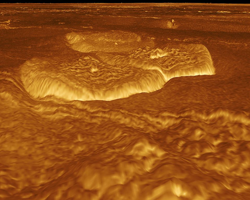
English: A portion of the eastern edge of Alpha Regio is displayed in this three-dimensional perspective view of the surface of Venus. The viewpoint is located at approximately 30 degrees south latitude, 11.8 degrees east longitude at an elevation of 2.4 kilometers (3.8 miles). The view is to the northeast at the center of an area containing seven circular dome-like hills. The average diameter of the hills is 25 kilometers (15 miles) with maximum heights of 750 meters (2,475 feet). Three of the hills are visible in the center of the image. Fractures on the surrounding plains are both older and younger than the domes. The hills may be the result of viscous or thick eruptions of lava coming from a vent on the relatively level ground, allowing the lava to flow in an even lateral pattern. The concentric and radial fracture patterns on their surfaces suggests that a chilled outer layer formed, then further intrusion in the interior stretched the surface. An alternative interpretation is that domes are the result of shallow intrusions of molten lava, causing the surface to rise. If they are intrusive, then magma withdrawal near the end of the eruptions produced the fractures. The bright margins possibly indicate the presence of rock debris or talus at the slopes of the domes. Resolution of the Magellan data is about 120 meters (400 feet). Magellan's synthetic aperture radar is combined with radar altimetry to develop a three-dimensional map of the surface. A perspective view is then generated from the map. Simulated color and a process called radar-clinometry are used to enhance small-scale structures. The simulated hues are based on color images recorded by the Soviet Venera 13 and 14 spacecraft. The image was produced by the JPL Multimission Image Processing Laboratory by Eric De Jong, Jeff Hall, Myche McAuley, and Randy Kirk of the United States Geological Survey, and is a single frame from the movie released at the May 29, 1991 Magellan news conference.
Čeština: Útvary na planetě Venuši, východně od Alpha Regio. Obraz byl vytvořen v laboratoři JPL Multimission Image Processing Laboratory, autory jsou Eric De Jong, Jeff Hall, Myche McAuley a Randy Kirk. Obraz byl získán metodou radarové klinometrie (měření sklonu) a je vyobrazen v nepravých barvách. |
| Datum | |
| Quelle | http://photojournal.jpl.nasa.gov/catalog/PIA00246 |
| Urheber | NASA, JPL Multimission Image Processing Laboratory, U.S Geological Survey |
| Genehmigung (Weiternutzung dieser Datei) |
http://nssdc.gsfc.nasa.gov/photo_gallery/photogallery-faq.html#use |
Diese Mediendatei wurde vom Jet Propulsion Lab der US-amerikanischen National Aeronautics and Space Administration (NASA) unter der Datei-ID PIA00246 kategorisiert. Diese Markierung zeigt nicht den Urheberrechtsstatus des zugehörigen Werks an. Es ist in jedem Falle zusätzlich eine normale Lizenzvorlage erforderlich. Siehe Commons:Lizenzen für weitere Informationen. Sprachen:
|
Lizenz
| Diese Datei ist gemeinfrei (public domain), da sie von der NASA erstellt worden ist. Die NASA-Urheberrechtsrichtlinie besagt, dass „NASA-Material nicht durch Urheberrecht geschützt ist, wenn es nicht anders angegeben ist“. (NASA-Urheberrechtsrichtlinie-Seite oder JPL Image Use Policy). | ||
 |
Warnung:
|
Dateiversionen
Klicke auf einen Zeitpunkt, um diese Version zu laden.
| Version vom | Vorschaubild | Maße | Benutzer | Kommentar | |
|---|---|---|---|---|---|
| aktuell | 23:13, 1. Sep. 2005 | | 5.000 × 4.000 (1,17 MB) | Bricktop | larger |
Dateiverwendung
Die folgende Seite verwendet diese Datei: