| Jewiki unterstützen. Jewiki, die größte Online-Enzyklopädie zum Judentum.
Helfen Sie Jewiki mit einer kleinen oder auch größeren Spende. Einmalig oder regelmäßig, damit die Zukunft von Jewiki gesichert bleibt ... Vielen Dank für Ihr Engagement! (→ Spendenkonten) |
How to read Jewiki in your desired language · Comment lire Jewiki dans votre langue préférée · Cómo leer Jewiki en su idioma preferido · בשפה הרצויה Jewiki כיצד לקרוא · Как читать Jewiki на предпочитаемом вами языке · كيف تقرأ Jewiki باللغة التي تريدها · Como ler o Jewiki na sua língua preferida |
Datei:Satellite image of Bolivia in June 2002.jpg
Zur Navigation springen
Zur Suche springen

Größe dieser Vorschau: 521 × 600 Pixel. Weitere Auflösungen: 208 × 240 Pixel | 417 × 480 Pixel | 667 × 768 Pixel | 889 × 1.024 Pixel | 5.279 × 6.079 Pixel.
Originaldatei (5.279 × 6.079 Pixel, Dateigröße: 4,02 MB, MIME-Typ: image/jpeg)
Beschreibung
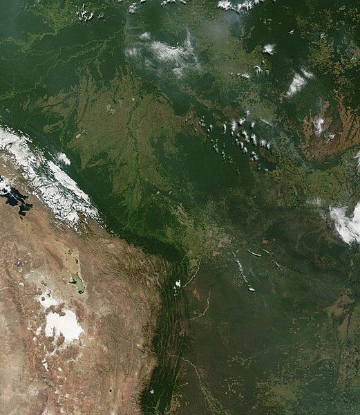
| Beschreibung | Satellite image of Bolivia in June 2002. Normally obscured by clouds, Bolivia is amazingly clear in this true-color MODIS image acquired June 20, 2002. Bounded by Brazil to the north and east, Paraguay and Argentina to the south, and Peru and Chile to the west, Bolivia is completely landlocked. A good portion of Bolivia is dominated by the Andes, but it also lays claim to lush forests and pasture lands in the Amazon Basin.Bolivia's agricultural crops include soybeans, coffee, coca, cotton, corn, sugarcane, rice, potatoes, and timber. A number of agricultural plots are visible in central Bolivia. Some large plots are arranged in a circular star shape, with water sources at the center and the agricultural plots radiating outwards. Adjacent to them (down and to the right) are more traditional shaped plots (more rectangular).One of Bolivia's main exports is tropical timber. Visible in this image are areas where the timber has been harvested. The deforestation patterns tend to follow major roads first, then smaller roads adjoining main roads. These patterns resemble the growth of ice crystals and are best viewed in the higher resolutions of this image. Deforestation is visible along the green edge of the Andes in central Bolivia. |
| Datum | |
| Quelle | Slightly cropped from: http://visibleearth.nasa.gov/view_rec.php?id=3261 |
| Urheber | Jacques Descloitres, MODIS Land Rapid Response Team, NASA/GSFC |
Lizenz
| Diese Datei ist gemeinfrei (public domain), da sie von der NASA erstellt worden ist. Die NASA-Urheberrechtsrichtlinie besagt, dass „NASA-Material nicht durch Urheberrecht geschützt ist, wenn es nicht anders angegeben ist“. (NASA-Urheberrechtsrichtlinie-Seite oder JPL Image Use Policy). | ||
 |
Warnung:
|
Dateiversionen
Klicke auf einen Zeitpunkt, um diese Version zu laden.
| Version vom | Vorschaubild | Maße | Benutzer | Kommentar | |
|---|---|---|---|---|---|
| aktuell | 18:40, 18. Dez. 2004 | | 5.279 × 6.079 (4,02 MB) | Hautala | {{PD-USGov-NASA}} Satellite image of Bolivia in June 2002. Slightly cropped image taken originally from http://visibleearth.nasa.gov/cgi-bin/viewrecord?16839 . Normally obscured by clouds, Bolivia is amazingly clear in this true-color MODIS image acquired |
Dateiverwendung
Die folgende Seite verwendet diese Datei: