| Jewiki unterstützen. Jewiki, die größte Online-Enzyklopädie zum Judentum.
Helfen Sie Jewiki mit einer kleinen oder auch größeren Spende. Einmalig oder regelmäßig, damit die Zukunft von Jewiki gesichert bleibt ... Vielen Dank für Ihr Engagement! (→ Spendenkonten) |
How to read Jewiki in your desired language · Comment lire Jewiki dans votre langue préférée · Cómo leer Jewiki en su idioma preferido · בשפה הרצויה Jewiki כיצד לקרוא · Как читать Jewiki на предпочитаемом вами языке · كيف تقرأ Jewiki باللغة التي تريدها · Como ler o Jewiki na sua língua preferida |
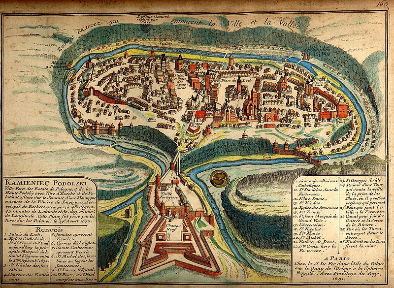
Datei:Kamianets-Podilskyi map 1691.jpg

Originaldatei (2.296 × 1.680 Pixel, Dateigröße: 1,58 MB, MIME-Typ: image/jpeg)
Beschreibung
| Beschreibung |
Українська: Давня французька мапа Кам'янця-Подільського 1691 після його захоплення турками
Русский: Старинная карта Каменца-Подольского 1691 года. |
||||||||||||||||||||
| Legende |
Français : KAMIENIEC PODOLSKI Ville forte des Estats de Pologne, et de la Haute Podolie avec Titre d'Evéché et de Palatinat, située sur le Sommet d’une Montagne entourée de la Riviere de Smotrycz, et envelopée de Rochers escarpez, à 48. degrez 45. minutes de Latitude et 50. deg. 10. min. de Longitude. Cette Place fut prise par les Turcs sur Polonais le 29e Aoust 1672. Renvois
A PARIS |
||||||||||||||||||||
| Datum | |||||||||||||||||||||
| Quelle | brooks-planck.org | ||||||||||||||||||||
| Urheber |
|
||||||||||||||||||||
| Georeferenzierung | If inappropriate please set warp_status = skip to hide. | ||||||||||||||||||||

Fortified city of the Polish State and of Upper Podolia, with the title of bishopric and palatinate [voivodeship], situated on top of a mountain surrounded by the Smotrycz River and enclosed by steep rocks, at 48°45’ latitude and 50°10’ longitude. This place was taken by the Turks from the Poles on 29 August 1672.
References
- Lech’s Palace
- Cathedral church of St Peter and St Paul, today the main mosque where the Grand Vizier entered on 3 September 1672
- St Nicholas’ [church] of the Dominicans
- Franciscan monastery
- Jesuits’ [church], now a stable
- Discalced Carmelites’ [church]
- St Catherine’s [church], now a stable
- Jesuits’ [church] of St Michael where the janissaries are quartered
- St Lazarus Hospital
- St Peter’s and St Paul’s [church], previously Ruthenian [Orthodox], today Catholic
- St Stanislaus’ [church] in the fortress
- Our Lady’s [church]
- St Nicholas’ [church]
- Armenian [Orthodox] church
- Holy Trinity [church]
- St John’s [church, now] Grand Vizier’s mosque
- Ascension [church]
- St Nicholas’ [church]
- St Mary’s [church]
- St Michael’s [church]
- Nativity [church]
- Holy Cross [church] outside the fortress
- St George’s [church], burnt
- Ruins of a tower which collapsed on the eve of the city’s capture, where 600 people perished
- Bridge linking the city with the fortress
- Canal linking the inlet and the outlet of the river
- [Place] where the Turks entered the moat
- Place where the Turks planted a mine
[Made] in Paris
At Mr. [Nicolas] De Fer’s [workshop] on the Palace Island on the Clock Quay at the Royal Sphere. With royal privilege, 1691.
Full text of the legend
| Bildnotizen | Diese Datei ist annotiert: Betrachte diese auf Commons. |
Lizenz
|
Dieses Werk ist gemeinfrei, weil seine urheberrechtliche Schutzfrist abgelaufen ist. | |
| Es wurde festgestellt, dass diese Datei frei von bekannten Beschränkungen durch das Urheberrecht ist, alle verbundenen und verwandten Rechte eingeschlossen. | |
Auszeichnungen
|

Dateiversionen
Klicke auf einen Zeitpunkt, um diese Version zu laden.
| Version vom | Vorschaubild | Maße | Benutzer | Kommentar | |
|---|---|---|---|---|---|
| aktuell | 01:29, 19. Okt. 2007 | | 2.296 × 1.680 (1,58 MB) | DDima | {{Information |Description={{en|An 1691 map of the Ukrainian City of Kamianets-Podilskyi.}} {{ru|Старинная карта Каменца-Подольского 1691 года}} |Source=[[:ru:Изображени |
Dateiverwendung
Die folgende Seite verwendet diese Datei: