| Jewiki unterstützen. Jewiki, die größte Online-Enzyklopädie zum Judentum.
Helfen Sie Jewiki mit einer kleinen oder auch größeren Spende. Einmalig oder regelmäßig, damit die Zukunft von Jewiki gesichert bleibt ... Vielen Dank für Ihr Engagement! (→ Spendenkonten) |
How to read Jewiki in your desired language · Comment lire Jewiki dans votre langue préférée · Cómo leer Jewiki en su idioma preferido · בשפה הרצויה Jewiki כיצד לקרוא · Как читать Jewiki на предпочитаемом вами языке · كيف تقرأ Jewiki باللغة التي تريدها · Como ler o Jewiki na sua língua preferida |
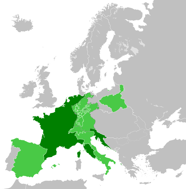
Datei:French Empire (1812).svg
Zur Navigation springen
Zur Suche springen


Größe der PNG-Vorschau dieser SVG-Datei: 450 × 456 Pixel. Weitere Auflösungen: 237 × 240 Pixel | 474 × 480 Pixel | 592 × 600 Pixel | 758 × 768 Pixel | 1.011 × 1.024 Pixel.
Originaldatei (SVG-Datei, Basisgröße: 450 × 456 Pixel, Dateigröße: 632 KB)
Beschreibung


.svg)
.svg)
.svg)
.svg)
.svg)


.svg)
.svg)
.svg)


.png)
.png)


.svg)


.svg)

.svg)


.svg)
.svg)
.svg)
.svg)


.svg)
.png)


.svg)


.svg)
.svg)


.svg)


.svg)


.svg)
.svg)
.svg)
.svg)
.svg)
.svg)
.svg)
.svg)
_cropped.svg)
.svg)
.svg)
.svg)
.svg)
.svg)
.svg)
.svg)
.svg)
.svg)
.svg)
.svg)
.svg)
.svg)
.svg)
.svg)
.svg)
.svg)
.svg)
.svg)
.svg)
.svg)
.svg)
.svg)
.svg)
.svg)
.svg)
.svg)
.svg)
.svg)
.svg)
.svg)
.svg)
.svg)
.svg)
.svg)
.svg)
.svg)
.svg)
.svg)
.svg)
.svg)
.svg)
.svg)
.svg)
.svg)
Dateiversionen
Klicke auf einen Zeitpunkt, um diese Version zu laden.
| Version vom | Vorschaubild | Maße | Benutzer | Kommentar | |
|---|---|---|---|---|---|
| aktuell | 00:32, 31. Mai 2019 | | 450 × 456 (632 KB) | Cplakidas | correcting the Ionan Islands: they were not a client state, but annexed to France; and by 1812, most of them apart from Corfu and Paxoi (not depicted in this map) were under British control. |
Dateiverwendung
Die folgende Seite verwendet diese Datei:
.svg)